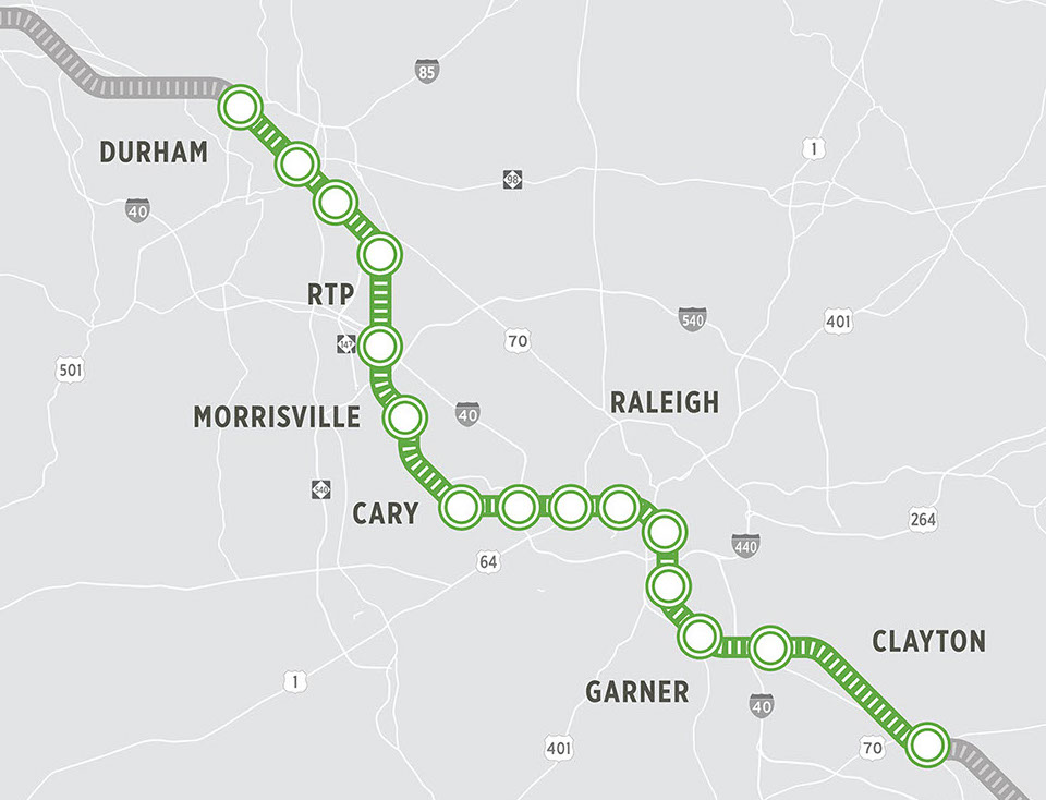
West Durham
Nearby Destinations
Within .5 mi: Duke University Hospital and VA Hospital; Within 1 mi: Duke University (East Campus approx. 1 mi east, West Campus approx. 1 mi south), Ninth Street shops and dining, 1 mi east
Nearby Transit
GoDurham 11/11B (W Main St – Duke/VA ), 6 (Chapel Hill St – Duke/VA – Crest Street), Duke Transit Routes, Future North Durham Crosstown Route (Duke Regional – North Duke Crossing)
Bike/Pedestrian Connections
Connected to existing sidewalk network north of NC 147; convenient pedestrian link to the south (hospitals, Duke West Campus) should be pursued.
Park-and-Ride
Medium surface parking lot serving northwest Durham and points west.
Downtown Durham
Nearby Destinations
Within .25 mi: Downtown offices, shops and dining, Brightleaf Square, American Tobacco Campus, Durham Innovation District; Within .5 mi: Durham Bulls Athletic Park, DPAC, Durham Farmer’s Market, Durham County Justice Center, Durham City Hall, Durham County offices
Nearby Transit
GoDurham bus hub, GoTriangle Routes 400, 405, 700, ODX, Amtrak, Greyhound, Megabus
Bike/Pedestrian Connections
Connected to extensive existing sidewalk network; Durham Belt Line greenway (in progress by City of Durham) would connect to this site. American Tobacco Trail / East Coast Greenway nearby.
East Durham
Nearby Destinations
Within .25 mi: Durham Green Flea Market; Within 1 mi: NCCU, Durham Tech, Hayti Heritage Center, Golden Belt
Nearby Transit
GoDurham 2 (Brier Creek), 12/12B (NCCU – Southpoint); Future East Durham Crosstown Route (Village – NCCU – Durham Tech)
Bike/Pedestrian Connections
Existing sidewalk network to the north and south will be enhanced upon completion of the Alston Avenue Widening Project, which will also include bike lanes; the R. Kelly Bryant Bridge Trail (in progress by City of Durham) will connect this proposed station area to the north and south to Durham Tech; south of 147, the Pearsontown Trail connects to NCCU.
Park-and-Ride
Small surface parking lot serving East Durham neighborhoods
Ellis Road
Nearby Destinations
Within .5 mi: Research Triangle Charter Academy, multifamily and single-family neighborhoods; Within 1 mi: North RTP employers, easy access from NC 147, future I-885, and future US 70 freeway
Nearby Transit
RTP Connect on-demand service, Future GoDurham East Durham on-demand service
Bike/Pedestrian Connections
Existing sidewalk on north side of Ellis Road; additional bicycle and pedestrian connectivity should be pursued to adjacent development and surrounding communities
Park-and-Ride
Medium surface parking lot serving northern and eastern Durham County
RTP/Regional Transit Center
Nearby Destinations
Within .25 mi: Fidelity, Park Point adaptative reuse offices, Davis Park; Within .5 mi: US Citizenship and Immigration Services, easy access from I-40, Within 1 mi: HUB RTP
Nearby Transit
Planned new GoTriangle Regional Transit Center with bus routes serving HUB RTP, Imperial Center, Perimeter Center, Greater RTP, RDU Airport, Apex, Chapel Hill, Morrisville, Cary, and Raleigh; GoDurham Route 12B (NC 55, NCCU), RTP Connect and Morrisville Smart Shuttle on-demand services
Bike/Pedestrian Connections
Existing sidewalk on north side of NC 54; additional bicycle and pedestrian connectivity should be pursued. Future Triangle Bikeway connecting to HUB RTP, future extension of Faulkner Street connecting to Davis Park
Park-and-Ride
Medium-large surface parking lot serving South Durham.
Morrisville
Nearby Destinations
Within .25 mi: Church Street Park; Within .5 mi: Wake Tech Community College RTP Campus, Perimeter Park offices and apartments; Within 1 mi: easy access from NC 540
Nearby Transit
GoTriangle 310 (Cary – Wake Tech – RTC), RDU shuttle, Morrisville Smart Shuttle on-demand service
Bike/Pedestrian Connections
Some sidewalks currently present along the east side of Chapel Hill Road; NC 2 Mountains to Sea state bike route crosses NC 54 at McCrimmon Parkway near the proposed station area, sidewalks and bike lanes will be integrated into McCrimmon Parkway widening and grade separation (NCDOT U-5747), planned pedestrian connections are part of Morrisville’s development plans in this area.
Park-and-Ride
Small surface parking lot serving Morrisville
Downtown Cary
Nearby Destinations
Within .25 mi: Downtown offices, shops, and dining, Page-Walker Arts Center, Cary Town Hall; Within.5 mi: Cary Library, Cary Arts Center, Downtown Cary Park
Nearby Transit
Proposed station will be integrated into the Downtown Cary Multi-modal Transit Facility; current transit connections include Amtrak, All GoCary Routes, GoTriangle 300 (Cary – Raleigh), 301 (Cary – Raleigh), 310 (Cary – Morrisville – RTP)
Bike/Pedestrian Connections:
Connected to extensive existing sidewalk network
Park-and-Ride
Small surface parking lot serving Cary, potential shared parking deck at Downtown Cary Multi-modal Facility
Corporate Center Drive
Nearby Destinations
Within .25 mi: Corporate Center Drive Offices; Within .5 mi: Easy access from I-40; Within 1 mi: WakeMed Soccer Park
Nearby Transit
GoRaleigh 26 (Edwards Mill – Crabtree Valley Mall)
Bike/Pedestrian Connections
Bicycle and pedestrian connectivity should be pursued.
Park-and-Ride
Small-medium surface lot serving Cary and West Raleigh
Blue Ridge Road
Nearby Destinations
Within .25 mi: NC State Fairgrounds, Caterpillar, NCDOT, NCSU West Campus & College of Veterinary Medicine; Within 1 mi: Carter Finley Stadium (NCSU), PNC Arena (Hurricanes & Concerts), Meredith College, easy access to I-440
Nearby Transit
NCSU Wolfline, GoTriangle 100, 105 (Raleigh – RTC), GoRaleigh 27 (Blue Ridge – Crabtree Valley Mall)
Bike/Pedestrian Connections
Sidewalk and Bike lanes will be included in the Blue Ridge grade separation (NCDOT U-4437) on Blue Ridge Road and Hillsborough Street. Blue Ridge Road Bike and Pedestrian Corridor project to connect to NC Museum of Art, future NC Department of Health and Services Campus, and UNC Rex Hospital (underway by City of Raleigh). Additional bicycle and pedestrian connectivity on Hillsborough street should be pursued.
Park-and-Ride
Medium-large surface lot serving West Raleigh and the Beltline.
NCSU
Nearby Destinations
Within .25 mi: NCSU Main Campus; Within .5 mi: Hillsborough Street shops and dining; Pullen Park, Within 1 mi: Village District shops and dining (former Cameron Village)
Nearby Transit
NCSU Wolfline, GoRaleigh 4 (Rex Hospital), GoTriangle 100, 105 (Raleigh – RTC), CRX (Chapel Hill), Future GoRaleigh 8 (Hillsborough Street)
Bike/Pedestrian Connections
Connected to extensive existing sidewalk network
Downtown Raleigh
Nearby Destinations
Within .25 mi: Downtown offices, shops, and dining, Warehouse District; Within .5 mi: Red Hat Amphitheatre, Raleigh Convention Center, Fayetteville Street, GoRaleigh Station, Glenwood South; Within 1 mi: Duke Energy Center for the Performing Arts, Shaw University, William Peace University, North Carolina State Capitol, NC General Assembly, State Administrative Offices, North Carolina Museum of History, North Carolina Museum of Natural Sciences, Dorothea Dix Park; Within 2 mi: Saint Augustine’s University.
Nearby Transit
Amtrak, GoRaleigh R Line, and Routes 8 & 13; Raleigh Union Station Bus facility (underway by GoTriangle) to connect to numerous GoTriangle and GoRaleigh routes, including Wake BRT
Bike/Pedestrian Connections
Connected to extensive existing sidewalk network
Southeast Raleigh
Nearby Destinations
Within .25 mi: Mexican Consulate, Within .5 mi: Garner Road Community Center, Duke Energy Customer Service Center, within 1.5 mi: future Downtown South development
Nearby Transit
GoRaleigh 22 (Garner), future Wake BRT
Bike/Pedestrian Connections
Bicycle and pedestrian connectivity should be pursued.
Park-and-Ride
medium surface lot serving Southeast Raleigh
Garner
Nearby Destinations
Within .25 mi: Garner Performing Arts Center, N. Garner Middle School, Avery Street Park and Recreation Center, nearby single-family and multi-family neighborhoods; Within .5 mi: Main Street shops and dining, Garner Senior Center
Nearby Transit
GoRaleigh 20 (Garner)
Bike/Pedestrian Connections
Sidewalks present, additional bicycle and pedestrian connectivity should be pursued.
Park-and-Ride
small surface lot serving Garner
Auburn
Nearby Destinations
Planned Transit Oriented Development by Town of Garner. Easy access from US 70 business, I-40 and future NC-540
Bike/Pedestrian Connections
Bicycle and pedestrian connectivity should be pursued.
Park-and-Ride
Large surface lot serving Southeastern Wake County, Clayton, and western Johnston County
Clayton
Nearby Destinations
Within 1 mi: Caterpillar, Within 2 mi: Downtown Clayton shops and dining, Grifols, Novo Nordisk, Natvar,easy access from NC 42, US 70, future I-42
Nearby Transit
No current transit connections; CAMPO is currently planning a bus route between Garner and Clayton
Bike/Pedestrian Connections
Bicycle and pedestrian connectivity should be pursued.
Park-and-Ride
large surface lot serving Clayton, Wilson’s Mills, Selma, Smithfield and Johnston County